The Daily has already reported the document this page belongs to: the 60-page investigation report written in 2010 by Bigelow Aerospace Advanced Space Studies — BAASS — the contractor that ran the Defense Intelligence Agency’s AAWSAP investigation at Skinwalker Ranch in Utah’s Uinta Basin. The report’s investigators interviewed witnesses, collected accounts of creatures, lights and a “portal,” and sent a hair sample for DNA testing. One page of the file does something different from all that prose. It plots the ranch from above, and marks where everything was said to happen.
The Ground Itself
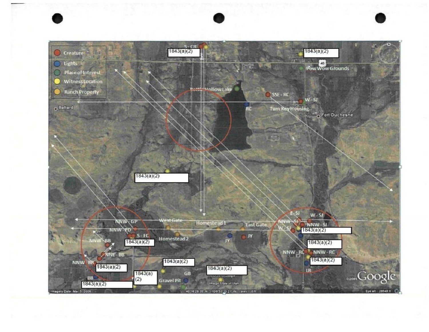
The page is a satellite image — Google Earth imagery dated March 5, 2009, printed and three-hole-punched for the report binder. It looks down on the ranch and its surroundings near Fort Duchesne, Utah. Bottle Hollow Lake, the dark reservoir at the top center of the frame, is the map’s anchor. Labels name the landmarks the investigation revolved around: Homestead 1 and Homestead 2 in the southern half of the property, the West Gate and East Gate on the road between them, a gravel pit to the south. Around the ranch, the map also names Ballard to the west, the Pow Wow Grounds and Highway 40 to the northeast, and Fort Duchesne itself to the east, with a cluster of buildings marked “Turn Key Housing.”
Five Colors Of Reported Things
The legend in the upper-left corner is the key to the whole page, and it is short. A red dot means Creature. A blue dot means Lights. A green dot means Place of Interest. A yellow dot means Witness Location. An orange dot means Ranch Property. Dozens of the dots are scattered across the frame, each tagged with a short code — NNW-GP, NNW-BB, S-FC, SSE-RC, W-SJ, JY, GB, LR and others — the report’s shorthand for the stations, witnesses or locations in its pages. Long white arrows run diagonally across the map, drawn from point to point: lines of sight, connecting where a witness stood to where a thing was seen.
Three areas are circled in red, in a hand heavy enough to show through the satellite image. One ring sits over Bottle Hollow Lake. One wraps the homestead cluster in the southwest, where the witness-location and creature markers are thickest. One wraps the cluster of coded points on the eastern side of the frame. The map does not explain the circles; it simply marks them — the places where the plotted reports gather.
The White Boxes
And then there are the redactions. At least ten white boxes are laid over the map, and every one of them is stamped with the same citation: 1843(a)(2). They cover names and labels — along the northern edge, beside the homesteads, over points in both circled clusters, down by the gravel pit. Whatever the investigators wrote at those spots, the released page does not show it. What the release gives the public is the shape of the investigation — where things were reported, and how the reports bunched together — with the identities underneath the boxes left blank.
What The Map Is, And Is Not
The map is not evidence of any single claim in the report. It is something plainer, and in its way rarer: the working geography of a government-funded investigation into phenomena the investigators could not explain — the ranch as they organized it, with creature sightings pinned in red and witness stands pinned in yellow, on a satellite page anyone can now read for themselves. The Pentagon released it on Friday, October 23, as part of the seventh PURSUE release, alongside the investigation report it illustrates. The Daily’s account of that report — the interviews, the six-foot figures, the hair sample and its DNA result — is here: “New UFO Files Detail Sightings of Six-Foot ‘Skinwalkers’ and ‘Portal to Another World’ Near America’s Famous Paranormal Hotspot.”
The Map, In Short
The page: a satellite map of Skinwalker Ranch and Bottle Hollow Lake, near Fort Duchesne, Utah, published in PURSUE Release 07 (October 23, 2026) as part of the 60-page BAASS investigation report written for the DIA’s AAWSAP program in 2010.
The imagery: Google Earth, dated March 5, 2009; the printed page is three-hole-punched for the report binder.
The legend: red — Creature; blue — Lights; green — Place of Interest; yellow — Witness Location; orange — Ranch Property.
The landmarks named: Bottle Hollow Lake, Homestead 1, Homestead 2, West Gate, East Gate, Gravel Pit; Ballard, the Pow Wow Grounds and Fort Duchesne around the property.
The markings: dozens of coded points, white sight-line arrows crossing the frame, and three red circles — over Bottle Hollow Lake, over the homestead cluster, and over the eastern cluster of points.
The redactions: at least ten white boxes, each stamped 1843(a)(2), covering names and labels throughout the map.
The Daily’s Release 07 Coverage
New UFO Files Detail Sightings of Six-Foot ‘Skinwalkers’ and ‘Portal to Another World’ Near America’s Famous Paranormal Hotspot · The Lead B-52 On History’s First Jet Flight Around The World Tracked An Unknown Over Saudi Arabia · New UFO Files Detail 1,800 MPH Black Triangle Near Military Sites · The Pentagon’s New UFO Files Include The Roswell Officer’s 2026 Statement
Sources: the map page and the BAASS investigation report, PURSUE Release 07, Department of War (war.gov/UFO), October 23, 2026; satellite imagery by Google Earth (March 5, 2009) as published in the report.
Comments
From the readers of the Daily.